Hyder Hot Springs
Nevada, United States
A remote cluster of hot seeps, travertine terraces and stubby tufa mounds at the north end of Dixie Valley, on open BLM range with one makeshift soaking pool and no facilities.
- Water temperature
- Not published
- Entry
- Free
- Getting in
- Drive-up
- Type
- Wild & natural
- Springs and seeps range from about 82°F to 174°F28°C to 79°C at their sources, so the soaking pool needs a careful hand test.
- The water builds carbonate mounds and travertine terraces along a line of young faults.
- On BLM land with no fee, no facilities and very few visitors.
- One of several thermal clusters in the Dixie Valley geothermal area, alongside Dixie and McCoy Hot Springs.
What to expect
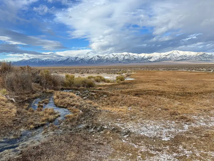
Hyder Hot Springs is one of the quieter thermal sites in Nevada, a spread of seeps, small pits and at least two flowing springs on the open floor of northern Dixie Valley. There is no development, no signage worth mentioning and usually nobody else around. Cattle graze the valley, dust devils cross the flats in the afternoon, and the mountain ranges on either side are a long way off.
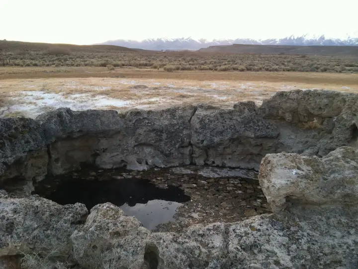
The springs rise along a zone of young faults that cut through the valley fill. Over time the mineral-rich water has built carbonate mounds and travertine terraces, and several short, stubby tufa mounds stand among the sources. Survey records list the spring temperatures as anywhere from about 82°F to 174°F28°C to 79°C, or roughly 82°F to 174°F28°C to 79°C. The hottest vents can scald.
Soakers use a pool that collects water from one of the very hot flows. It is a makeshift basin, not a built tub, and its temperature changes with the weather, the wind and how the flow has been managed by the last visitor. Some days it will be too hot to use.
Hyder is part of the larger Dixie Valley geothermal area, which also includes Dixie Hot Springs, McCoy Hot Springs and several other thermal clusters, and is home to one of Nevada’s long-running geothermal power plants. Geologists estimate the water feeding Hyder comes from a modest reservoir at about 183°F84°C, close to the hottest spring temperature.
Getting there
Hyder is remote, and this is the part of the trip that needs planning. The springs sit at about 3,560 feet near the northern end of Dixie Valley, just inside Pershing County where it meets Churchill County. There are no towns in this part of the valley.
Most people reach Dixie Valley from US 50 east of Fallon on Dixie Valley Road, then continue north on unpaved valley roads. We could not confirm a current, reliable turn-by-turn route to the springs, and roads in the valley change with ranch, grazing and geothermal activity. Before you go:
- Load the coordinates and an offline topographic map. Do not trust a phone app to route you on these roads.
- Fill the tank in Fallon or Lovelock and carry extra fuel if you plan to explore.
- Use a high-clearance vehicle. Some valley roads are graded, others are rough two-tracks with soft spots.
- Do not drive the dirt roads after rain or snowmelt. The valley floor turns to slick mud and can trap a vehicle for days.
Dixie Valley is also used for military flight training from Naval Air Station Fallon. Expect jets overhead, and check current BLM maps so your route stays on land open to the public.
When to go
Spring and fall are the best times. Days are mild and nights cold, which makes a hot pool worth the drive, and the roads are usually dry.
Summer is hot and dusty on the valley floor, with little shade. A very hot spring is hard to enjoy at midday in July.
Winter can be clear and cold, but storms make the roads risky, and help is a long way off if you get stuck.
Crowds are not an issue. You are more likely to see cows than people.
Rules and etiquette
- Free, public land. Hyder is on BLM land and there is no fee.
- Camping. Dispersed camping is generally allowed on BLM land in Nevada, typically up to 14 days in one spot. Camp well back from the springs so wildlife and cattle can still reach the water.
- Do not dig or build. Leave the travertine terraces and tufa mounds as you found them. They take a very long time to form and break easily.
- No soap in the pool or the outflow.
- Pack out everything, including toilet paper and food waste.
- Leave gates as you found them. This is working range.
What to bring
Pack as if nothing is available, because nothing is. Bring more drinking water than you think you need, a bucket or jug for cooling the pool with spring runoff if it is too hot, sandals with grip for the mineral crust, a trash bag, and a shovel or waste kit. A thermometer is worth carrying here. With source temperatures that range by almost 100 degrees between vents, it takes the guesswork out of choosing where to sit.
Where to stay nearby
There is no lodging or developed campground near the springs. Most visitors either camp on BLM land or base themselves in Fallon, which has motels, restaurants and supplies and is the usual starting point for a Dixie Valley trip. Lovelock on I-80 is another option with basic services. Both are long drives from the springs, so plan to arrive with daylight to spare.
Safety notes
- Scalding water. Some vents here run near 174°F79°C. Test any pool with your hand, keep children and dogs away from the sources, and do not step on soft or crusted ground near the vents.
- Head above water. Warm, still pools can hold harmful organisms. Do not put your head under.
- Remoteness. Expect no cell service. Tell someone where you are going and when you expect to be back, and carry plenty of water, a spare tire and recovery gear.
- Heat. There is no shade at the springs. In warm months, visit early or late.
- Livestock. Cattle use the springs as a water source. Give them room.
Nearby
Hyder is closer in spirit to the other free central Nevada springs than to the Reno resorts. For another Pershing County site with a very different story, see Kyle Hot Springs, an old resort on private land that is listed as closed.
Map and nearby springs
GPS: 40.00330, -117.71750
Hyder Hot Springs: common questions
Is Hyder Hot Springs on public land?
Yes. BLM surface-management data shows the springs on Bureau of Land Management land. There is no fee and no permit for a day visit.
How hot is Hyder Hot Springs?
The individual springs and seeps have been measured between about 82°F and 174°F28°C and 79°C (roughly 82°F to 174°F28°C to 79°C). The soaking pool is fed by a very hot flow, so its temperature depends on how much it has cooled. Always test it with your hand before getting in, and stay away from the source vents.
Where is Hyder Hot Springs?
At the north end of Dixie Valley in central Nevada, just inside Pershing County near the Churchill County line, at about 3,560 feet. It is part of the Dixie Valley geothermal area and is far from any town.
Can you camp at Hyder Hot Springs?
Dispersed camping is generally allowed on BLM land in Nevada, usually for up to 14 days. There are no facilities, so bring water and a way to pack out human waste, and camp well back from the springs.
Do you need four-wheel drive for Hyder Hot Springs?
We could not confirm the current road condition. The last miles are unpaved valley roads, so a high-clearance vehicle is the safe choice, and no vehicle should try them when they are wet.
Closest hot springs to Hyder Hot Springs
Near Unionville
Wild & natural
Near Gerlach
Wild & natural
All hot springs in NevadaAll hot springs in United StatesOpen the full map