Sulphur Creek Hot Springs
Near Darrington, Washington, United States
A tiny, piped warm-spring pool of about 90°F32°C on Sulphur Creek in the Glacier Peak Wilderness, off the upper Suiattle River Road. It is currently closed by a fire closure and a road washout.
Temporarily closed. Sulphur Creek Trail 793 and Sulphur Creek Campground are closed under the Miner's Fire closure order (Aug 15 to Dec 31, 2026, unless rescinded sooner). Suiattle River Road (FR 26) is also closed to motor vehicles from the Suiattle Mountain Road junction under order 06-05-26-03 through Jan 1, 2028, after flood damage.
- Water temperature
- 90°F32°C
- Entry
- Free
- Getting in
- Long hike
- Type
- Wild & natural
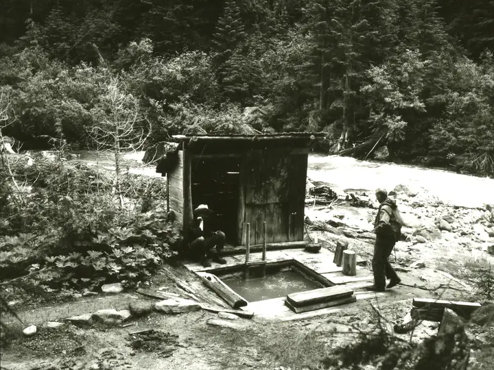
- One small primitive pool, fed by a pipe, holds about two people at roughly 90°F32°C.
- The Forest Service calls the springs undeveloped and difficult to find; the side path past the log bridge is faint.
- Trail 793 enters the Glacier Peak Wilderness about a quarter mile from the road.
- Closed in fall 2026: the trail by a fire closure order, and the road to motor vehicles until as late as January 2028.
Current status
Sulphur Creek Hot Springs is closed for now, and getting there will stay hard for a while after the fire closure ends.
- Fire closure: The Mt. Baker-Snoqualmie National Forest’s Miner’s Fire closure order took effect on August 15, 2026 and runs to December 31, 2026 unless it is rescinded sooner. It bans entry to a list of Darrington Ranger District roads, trails and sites, including Sulphur Creek Trail 793, Sulphur Creek Campground, the Suiattle Trailhead, the Suiattle River Trail and the Pacific Crest Trail between Mica Lake and Suiattle Pass.
- Road closure: Atmospheric river flooding badly damaged the Suiattle River Road (Forest Road 26). Order 06-05-26-03, signed April 2, 2026, closes FR 26 to all motor vehicles from the Suiattle Mountain Road junction to the Suiattle River Trailhead, along with several spur roads, through January 1, 2028 unless lifted sooner. The Forest Service alert places the closure at about milepost 4. The order only names motor vehicles, so walking or biking the road may be possible once the fire closure ends. Confirm that with the ranger station first.
Contact the Darrington Ranger Station, 1405 Emens Avenue North, Darrington, at (360) 436-1155. From October 2 it is open Mondays and Fridays, 8 a.m. to 4 p.m.
What to expect
Do not come here expecting a hot soak. Sulphur Creek Hot Springs is a single small pool beside Sulphur Creek in old forest near the Suiattle River, fed by a pipe from a warm seep. WTA describes it as more warm than hot, at about 90°F32°C, with room for two. Regular visitors leave a broom: you sweep the sediment off the bottom, open the pipe and wait about 20 minutes for it to fill.
The Forest Service calls the springs undeveloped and difficult to find, and the trail itself sees light use and little maintenance. WTA notes damage and blowdowns from the 2020 Downey Creek Fire, and the 2026 Miner’s Fire led to trail closures across this part of the Glacier Peak Wilderness. Expect to climb over logs and pick your way along a faint path.
A US Geological Survey mineral database entry records the geothermal site at about 1,880 feet in Snohomish County, on national forest land. The coordinates on this page come from that record and match the line of the trail on OpenStreetMap, but treat them as approximate.
There are no facilities at the pool. Pack out everything, including toilet paper.
Getting there
Under normal conditions:
- From Darrington, drive north about 8 miles on State Route 530 toward Rockport. From Highway 20 at Rockport, drive south on SR 530 instead.
- Turn east onto Suiattle River Road (FR 26) and cross the large bridge over the river.
- Follow FR 26 about 22 to 23 miles to Sulphur Creek Campground. The trailhead is directly across the road, on the north side. WTA asks hikers to park off the road but not in the campground.
- The trail climbs steeply at first and enters the Glacier Peak Wilderness after about a quarter mile. After roughly a mile it forks; the left branch heads for the springs.
- At the log bridge, continue about 0.1 mile up the creek. The path is faint here. Look for stone steps that lead down to the pool.
WTA lists the whole Sulphur Creek Trail at 3.6 miles round trip with about 900 feet of gain and a high point of 2,250 feet. No parking pass is listed.
With the road closed to cars from near milepost 4, the trailhead is roughly 18 miles of closed road beyond the gate. That makes it an overnight trip by bike or on foot at best, and only once the fire closure lifts.
When to go
In a normal year, summer and early fall are the practical season. Snow can linger in the upper Suiattle valley into early summer, and fall rain makes the creek-side scramble slick. The water is only about 90°F32°C, so a warm afternoon is a better match than a cold, wet day.
For 2026, there is no season: the trail is closed. For 2027, watch the Mt. Baker-Snoqualmie alerts page for the fire closure and for any change to the Suiattle River Road order.
Rules and etiquette
- Respect closures. Entering an area closed by forest order can bring fines of up to $5,000 for an individual.
- Wilderness rules apply inside the Glacier Peak Wilderness, which starts about a quarter mile up the trail. No motors or bikes past the boundary.
- Clothing: There is no forest-wide nudity order on the Mt. Baker-Snoqualmie. At a two-person pool this remote, clothing is up to the people sharing it. Ask before you strip if someone is already there.
- Do not dig or dam the creek to make a bigger pool, and leave the pipe and broom where you found them.
- No soap in the pool or the creek.
- Store food properly. The forest has a forest-wide food storage order requiring food to be kept in a bear-resistant manner, and a forest-wide 14-day limit on camping in one spot outside developed sites.
Where to stay nearby
- Sulphur Creek Campground is across the road from the trailhead. It is closed under the 2026 fire order and cannot be reached by car while FR 26 is closed.
- Darrington is the nearest town, about 30 road miles from the trailhead, with the ranger station, food and fuel.
- Rockport and Marblemount, on Highway 20 to the north, are the other bases if you come in from the north.
Safety notes
- Burned forest: Fire-killed trees fall without warning, especially in wind. Do not linger under dead snags, and do not camp near them.
- Route-finding: The last stretch is faint. Carry a map and a GPS track, and turn back if you lose the path.
- Water quality: The pool is not tested or treated. Keep your head above water and do not drink it.
- Remoteness: There is no cell service in the upper valley, and with the road closed, help is many miles away. Tell someone your plan and carry a satellite messenger if you go once the area reopens.
- Creek crossings: Sulphur Creek runs high and cold in early summer. Footing on wet logs and rocks is poor.
Map and nearby springs
GPS: 48.25500, -121.18030
Sulphur Creek Hot Springs: common questions
Is Sulphur Creek Hot Springs open?
Not in October 2026. The Miner's Fire closure order, in effect from August 15 to December 31, 2026 unless lifted sooner, closes Sulphur Creek Trail 793, Sulphur Creek Campground and the Suiattle Trailhead. Separately, Suiattle River Road is closed to motor vehicles from the Suiattle Mountain Road junction under order 06-05-26-03, which runs to January 1, 2028. Call the Darrington Ranger Station at (360) 436-1155 before planning a trip.
How hot is Sulphur Creek Hot Springs?
Warm rather than hot. The Washington Trails Association describes the pool as about 90°F32°C. It is a lukewarm soak, best on a warm day.
How long is the hike to Sulphur Creek Hot Springs?
Under normal conditions the trailhead is on Suiattle River Road about 22 to 23 miles from Highway 530, and WTA lists the Sulphur Creek Trail at 3.6 miles round trip with about 900 feet of gain. The springs are off a left fork after the first mile. While the road is closed to vehicles at the lower end, you would also face roughly 18 miles of road each way on foot or by bike.
How do you find the pool at Sulphur Creek?
WTA says to continue about 0.1 mile up the creek past the log bridge, where the path is faint, and look for stone steps leading to the pool. The Forest Service warns that the springs are hard to find. Carry a map and a GPS track, and do not trample new paths along the creek.
Can you camp near Sulphur Creek Hot Springs?
Sulphur Creek Campground sits across the road from the trailhead, but it is closed under the 2026 fire order and cannot be reached by car while the road is closed. Wilderness rules apply once the trail crosses the Glacier Peak Wilderness boundary.
Closest hot springs to Sulphur Creek Hot Springs
Near Darrington
Wild & natural
Near Skykomish
Resort or spa
100°F38°C
Wild & natural
Near Leavenworth
Resort or spa
104-111°F40-44°C
Resort or spa
Goldmyer Hot Springs
Washington, United States
54 mi away, ~1.5 hr drive
104-111°F40-44°C Paid Long hike
All hot springs in WashingtonAll hot springs in United StatesOpen the full map
Sources we checked (6)
- fs.usda.gov/r06/mbs/recreation/trails/sulphur-creek-trail-793
- fs.usda.gov/r06/mbs/alerts/miners-fire-closure-order
- fs.usda.gov/r06/mbs/alerts/suiattle-river-road-washout-closure
- wta.org/go-hiking/hikes/sulphur-creek
- wta.org/news/signpost/hiker-headlines-comment-now-about-ancient-lakes-camping-glacier-peak-wilderness-pct-fire-closures-8-20-26
- westernmininghistory.com/mine-detail/10253729/