Stanley Hot Springs
Near Lowell, Idaho, United States
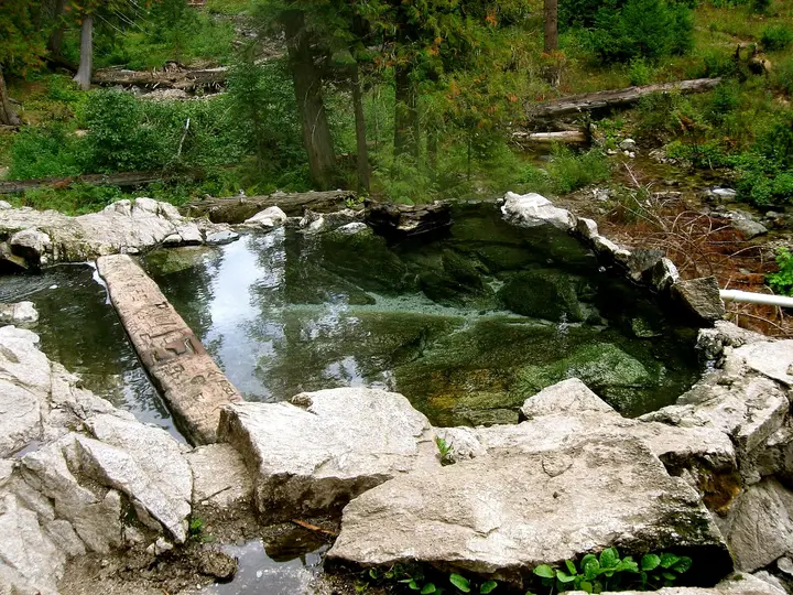
A chain of rock and log-dammed pools on Huckleberry Creek in the Selway-Bitterroot Wilderness, reached by a roughly 6-mile trail from Wilderness Gateway Campground on US-12 and an unbridged crossing of Boulder Creek.
Photo: Aaron (CC BY 2.0). Resized and cropped for this page.

- Water temperature
- 103-106°F39-41°C
- Entry
- Free
- Getting in
- Long hike
- Type
- Wild & natural
- Not near the town of Stanley. This spring is in the Selway-Bitterroot Wilderness off US-12 on the Lochsa River.
- About 6 miles each way on Trail 211 from Wilderness Gateway Campground at milepost 122.
- The Boulder Creek bridge washed out in the winter of 1998-99 and has not been replaced, so you ford or cross on logs.
- Pools in old-growth forest, with the best one measured at about 103°F39°C.
What to expect
Start with the name, because it trips people up. Stanley Hot Springs has nothing to do with the town of Stanley in the Sawtooth Mountains. It is in north-central Idaho, in the Selway-Bitterroot Wilderness, on Huckleberry Creek a few miles south of US-12 and the Lochsa River. If you were looking for a soak near Stanley, see the note at the end of this page.
This is a proper backcountry spring. You walk about 6 miles each way, cross a creek with no bridge, and arrive at a series of pools stepping down a slope through old, lush forest. The hot water runs through several rock and log-dammed pools before it reaches Huckleberry Creek, and the pools sit in a large clearing above the trail.
The spring is listed at about 106°F41°C at an elevation of roughly 3,580 feet. The water cools as it moves from pool to pool, so you can usually find a comfortable spot. A long-running Idaho hot springs directory measured its favourite pool, a deep and wide one, at 103°F39°C. The water is crystal clear with no smell.
Do not expect solitude. The same directory rates use as heavy to extreme, and plenty of people camp here. The trail is also open to stock, so horses and pack strings are part of the scene.
Getting there
The trailhead is at Wilderness Gateway Campground, on US-12 (the Northwest Passage Scenic Byway) at milepost 122, about 25 miles east of Lowell. The campground is in the Nez Perce-Clearwater National Forests.
- From Lewiston or Kooskia: Follow US-12 east up the Clearwater and then the Lochsa River. Wilderness Gateway is about 48 miles east of Kooskia.
- From Missoula: Cross Lolo Pass on US-12 and drive west down the Lochsa. Wilderness Gateway is about 85 miles west of Lolo, Montana.
Drive through the campground past the A and B loops to the trailhead parking. There is no parking fee for hikers.
The hike: Pick up Trail 211 (Boulder Creek Trail), which leaves on the left before the second bridge in the campground. It follows Boulder Creek upstream for about 5 miles to a signed junction. Go right toward Huckleberry Flat, cross Boulder Creek, then follow the edge of Huckleberry Creek to the pools. Total distance is roughly 6 miles each way. Reports describe the trail as rough and tiring, with a steady climb and plenty of horse traffic.
The Boulder Creek crossing: The bridge here washed out in the winter of 1998-99. As of 2021 the Forest Service had not announced plans to replace it. Hikers either ford the creek or head slightly downstream to a log jam, where logs zigzag across to a midstream island and a rope along a log helps with the final section. In spring runoff, and after heavy rain, this crossing can be too dangerous to attempt. Turn around rather than gamble.
A longer loop: Strong hikers sometimes link Trail 220 and Trail 221 (also numbered 2210) into a loop of about 20 miles that drops roughly 1,500 feet to the springs from the ridge. The Idaho Trails Association noted in 2024 that those trails inside the wilderness had not been cleared recently and that a 2024 hiker found burned, blown-down sections. Stick to Trail 211 unless you have current reports.
When to go
The best window is after spring runoff and before the snow. Boulder Creek runs high and fast in spring, which makes the crossing hard or impossible. By mid to late summer it drops, and the trail is at its easiest.
Late summer and early fall are the sweet spot: low water at the crossing, cooler nights that make the pools feel better, and fewer horse flies, which the directory reports can be bad in summer.
Winter trips are possible on snowshoes. The creek crossing is cold and icy, daylight is short and help is far away, so this is for experienced winter campers only. Confirm campground and trailhead access with the forest first.
Weekends in summer are busy. Midweek trips have a better chance of a quiet pool.
Rules and etiquette
- Wilderness rules apply. No motorized equipment and no mechanized transport, which includes bicycles, inside the Selway-Bitterroot Wilderness.
- Free. No permit or fee to hike in or soak.
- Camp on existing sites. The ground around the springs has been heavily damaged by people and horses. Use a site that is already there, keep tents off the vegetation, and do not build new fire rings.
- Yield to stock. Horses have the right of way. Step off the trail on the downhill side and stay still until they pass.
- No soap or shampoo in the pools, including biodegradable products.
- Clothing: We found no posted swimsuit rule for this spring. In practice, expect to see both. Bring a suit if you prefer one.
- Pack it out. That includes food waste, toilet paper and anything left by the last party you can carry.
Where to stay nearby
- Wilderness Gateway Campground is at the trailhead, with dozens of single sites, a large group site and an equestrian loop (Loop D) with hitching rails and a staging area for stock. There is drinking water, flush and vault toilets, paved parking spurs and fire rings, but no hookups. Some sites are first come, first served and others can be booked on Recreation.gov. Extra vehicles pay $2 a day.
- At the springs: Primitive sites in the clearing and nearby forest. Use existing ones.
- Lowell, about 25 miles west, and Kooskia, about 48 miles west, have the closest motels, fuel and food.
Safety notes
- The creek crossing is the main hazard on this trip. Scout it, unbuckle your pack’s hip belt, use poles, and do not cross alone in high water.
- Remoteness: There is no cell service at the campground. Recreation.gov notes the nearest town with reception is Kooskia, 49 miles away. Carry a satellite messenger for overnight trips and leave your plan with someone.
- Wildlife: Moose visit the pools, sometimes at dusk. Give them a wide berth. This is also black bear country, so hang food or use a bear canister.
- Heat: At about 103-106°F39-41°C the pools are comfortable but warm. Drink water, keep soaks short after a long hike, and do not put your head under.
- Trail condition: Fallen trees and washouts are common in this wilderness, and burned areas off the main trail shed trees in wind. Check with the Nez Perce-Clearwater National Forests (the campground line is 208-942-3113) before you go.
Nearby stops worth adding
US-12 has two more famous soaks east of Wilderness Gateway. Jerry Johnson Hot Springs is about a mile’s walk from a pack bridge between mileposts 151 and 152 and is day use only. Weir Creek Hot Springs, near milepost 142, was listed as closed until further notice by the regional tourism office because of visitor behaviour, so check before you plan around it.
If you came here looking for springs near the town of Stanley, try Sunbeam Hot Springs or Basin Creek Hot Springs on Highway 75 east of town.
Map and nearby springs
GPS: 46.31618, -115.25836
Stanley Hot Springs: common questions
Is Stanley Hot Springs near Stanley, Idaho?
No. Despite the name, it is in north-central Idaho, in the Selway-Bitterroot Wilderness south of US-12 and the Lochsa River. The town of Stanley is in the Sawtooth Mountains, a long drive to the south. The springs near Stanley are Sunbeam, Basin Creek and others along Highway 75.
How long is the hike to Stanley Hot Springs?
Roughly 6 miles each way. Trail 211 follows Boulder Creek from Wilderness Gateway Campground for about 5 miles to a signed junction. From there you head toward Huckleberry Flat, cross Boulder Creek and follow Huckleberry Creek to the pools. Many people make it an overnight trip.
Is there a bridge over Boulder Creek?
Not any more. The bridge washed out in the winter of 1998-99 and, as of 2021, the Forest Service had not announced plans to rebuild it. Hikers ford the creek or use a log jam slightly downstream of the old crossing. In runoff the creek can be impassable.
How hot is Stanley Hot Springs?
The spring is listed at about 106°F41°C. Pools cool as the water moves downhill, and one long-running Idaho directory measured its best pool, which was deep and wide, at 103°F39°C.
Can you camp at Stanley Hot Springs?
Yes. There are many established primitive sites at and around the springs. The area has been damaged by heavy use from hikers and horses, so use an existing site and do not clear a new one. Wilderness Gateway Campground at the trailhead is the base for most trips.
Is Stanley Hot Springs free?
Yes. There is no fee to hike in or to park at the trailhead past the A and B campground loops. Staying in Wilderness Gateway Campground costs a nightly fee.
Closest hot springs to Stanley Hot Springs
Wild & natural
Near Hamilton
Resort or spa
All hot springs in IdahoAll hot springs in United StatesOpen the full map