Skinny Dipper Hot Springs
Near Banks, Idaho, United States
A former set of user-built, pipe-fed soaking pools on a steep slope above the Banks-Lowman Highway. The BLM closed it in 2016 and the closure is still in force.
Temporarily closed. The BLM Four Rivers Field Office has closed the Skinny Dipper area to all uses since June 2016. The current order took effect February 14, 2022, for five years (to about February 2027) unless lifted sooner. No newer notice had been published as of October 2026.
Photo: BLMIdaho (Public domain). Resized and cropped for this page.

- Water temperature
- Not published
- Entry
- Free
- Getting in
- Short walk
- Type
- Wild & natural
- The whole 41.58-acre BLM parcel north of Highway 17 is closed to all uses, not just the pools.
- The current five-year order began on February 14, 2022, so it runs to about February 2027 unless the BLM ends it sooner.
- A rockslide soon after the 2016 closure filled the old pools, according to the BLM.
- Violators face a federal fine, up to 12 months in jail, or both.
Status: closed, and still closed in 2026
Skinny Dipper Hot Springs is closed. Please do not drive out expecting a soak.
The Bureau of Land Management closed the Skinny Dipper area in June 2016. In July 2021 the agency announced it would extend that closure for another five years, and the new order was published in the Federal Register in January 2022. It took effect at 12:01 a.m. on February 14, 2022, and lasts five years, unless the BLM rescinds or changes it first. That puts the end date at about February 2027.
We checked the Federal Register in October 2026 for any later notice that lifts, changes or replaces the order. There was none. The most recent document on Skinny Dipper is still the 2022 closure. So as of this update the order is in force.
The closure is wide. It covers all public land north of Idaho State Highway 17, the Banks-Lowman Highway, in one parcel about 4 miles east of Banks: Lot 3, Section 25, T. 9 N., R. 3 E., Boise Meridian, roughly 41.58 acres. All uses are banned, which means walking, sitting, soaking and camping. The only people allowed in are officials doing their jobs, rescue and firefighting crews, and anyone with written authorization from the BLM Four Rivers Field Office.
When February 2027 comes, do not assume the slope opens on its own. The BLM can extend the order again, as it did in 2022. Check with the field office first.
What Skinny Dipper was
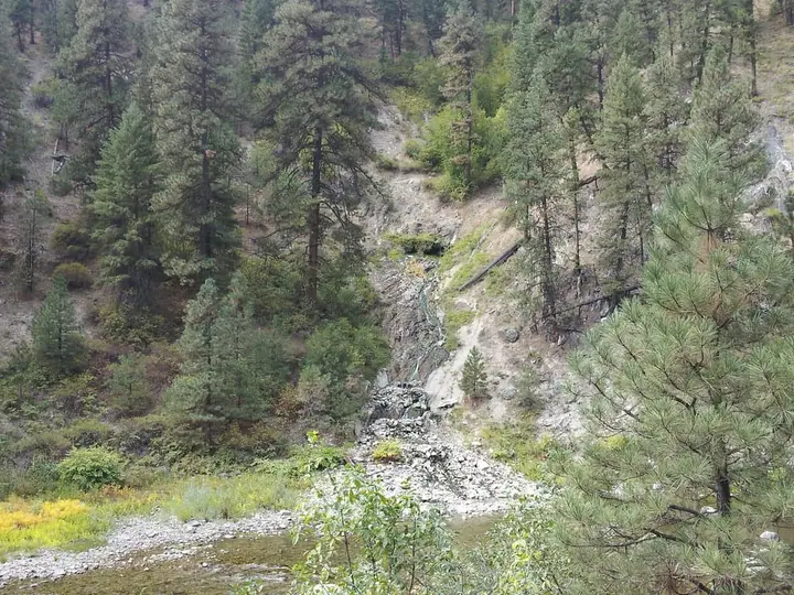
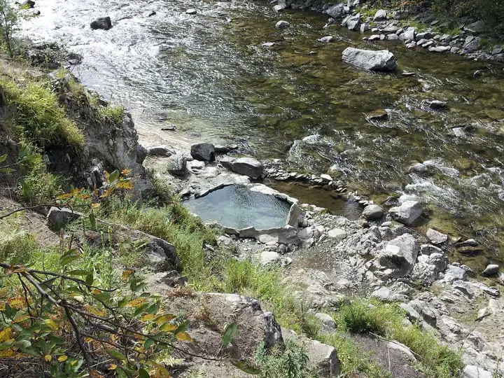
Skinny Dipper sat on a steep, brushy hillside above the South Fork Payette River, facing the river canyon. It was never a natural pool. Visitors built a series of soaking pools on the slope in the 1990s and ran piping to bring hot water down to them, all without permission on BLM land. It was free and close to a paved highway, so it became a popular soak for people driving up from Boise. Problems after dark led to repeated night-time closures, and in the end to a full shutdown.
Local news described the pools as about a half-mile walk up from the Banks-Lowman Highway. Visitors parked at a pullout on the river side, crossed the road and climbed a steep, loose path.
The name gives away the clothing habits. Nudity was common. Some visitors wore swimsuits anyway because the slope is so close to a busy road.
Soon after the 2016 closure, the BLM says, a natural rockslide filled the pools and left them largely unusable. The agency also planned to remove the piping and rehabilitate the access trail, and the 2022 extension was partly to give it time to finish that work. Do not expect to find the old pools intact even if the area reopens.
Why it was closed
The closure history goes back further than 2016:
- 2004: The BLM issued an emergency closure of the parking area, the trail and the area within 1,000 feet of the springs from sunset to sunrise, for public safety. That night closure ran until May 2009.
- 2012: A new sunset-to-sunrise restriction was imposed. In August 2012 a wildfire burned the slope, and in spring 2013 the BLM closed the area to all use for a few months because bare, burned ground above the springs raised the risk of rockfall and debris flows.
- 2015: The BLM announced plans to dismantle the site. Local groups appealed and proposed managing it themselves, including a daylight-only plan. The BLM said those proposals did not answer its health and environmental concerns.
- 2016: The full closure took effect in June. The field manager at the time pointed to repeated complaints from local law enforcement, nearby landowners and public health officials about dangerous and illegal activity.
- 2021-2022: The BLM took public comment on extending the closure. It said most comments supported an extension, and the five-year renewal began in February 2022.
Both the 2016 and later statements left one door open. The BLM said it would still consider a special use permit from a group that could clean up the site and manage it responsibly. No such permit has been reported.
Getting there (for reference only)
The site is on the Banks-Lowman Highway (Idaho 17), also signed as the Wildlife Canyon Scenic Byway. From Boise, drive north on Highway 55 to Banks, then turn east on Highway 17 along the South Fork Payette. The old pullout is about 4 miles east of Banks, on the river side of the road. Garden Valley and Crouch are further east.
The pullout itself sits beside a state highway, but the slope across the road is the closed BLM parcel. Do not cross the highway and climb it while the order stands. The canyon is also prone to mud and rock slides, especially after heavy rain or snowmelt.
When to go
There is no season to visit while the closure is in force. If the BLM ever reopens the area, expect new rules, likely including day-use limits, since night-time problems were behind every earlier order. Watch the BLM Idaho news releases and the Federal Register for any change, or call the Four Rivers Field Office.
Rules and etiquette
- The closure order is the rule. All uses of the closed land are banned.
- Penalties: Violators can be tried before a U.S. Magistrate, fined, jailed for up to 12 months, or all three. State and local officers can add Idaho charges.
- Exceptions: Only officials on duty, rescue and fire crews, and people with written BLM authorization.
- Contact: BLM Four Rivers Field Office, 3948 Development Avenue, Boise, Idaho 83705, phone 208-384-3300.
Where to soak instead
The same highway leads to soaks that are open, all on Boise National Forest land. A forest order bans public nudity on all Boise National Forest land from August 27, 2025, to August 27, 2030, so bring a swimsuit.
- Kirkham Hot Springs, just east of Lowman, has pools and hot waterfalls beside the South Fork Payette.
- Bonneville Hot Springs, further east on Highway 21, has rock pools and a small bathhouse a short walk from a Forest Service campground.
- Silver Creek Plunge, north of Crouch, is a family-run geothermal pool with cabins and campsites.
Check each one’s own page for current rules and fees.
Bronco Billy Hot Spring, also called Deer Creek Hot Springs, is on the same hillside. It is not named in the order, but it appears to be inside the same closed parcel or on its edge. Treat it as closed too.
Where to stay nearby
There is no camping at the pullout or on the closed slope. Garden Valley and Crouch, east along Highway 17, have cabins, RV parks, food and fuel. The Boise National Forest has campgrounds along the Banks-Lowman Highway and the Middle Fork Payette. Boise, the nearest city, is south on Highway 55.
Safety notes
- Unstable slope: The hillside burned in 2012 and has had rockfalls since. Loose rock and debris flows are a real risk after rain.
- Highway traffic: The pullout is on a winding two-lane canyon road. Pull fully off the pavement if you stop.
- Closure enforcement: Entering the closed area can lead to a federal citation.
Why this listing exists
Skinny Dipper still appears on old maps, apps and hot springs lists, often with no mention of the closure. We keep this page so anyone searching for it learns the current status first. We will update it when the BLM lifts, extends or replaces the order.
Map and nearby springs
GPS: 44.09222, -116.05060
Skinny Dipper Hot Springs: common questions
Is Skinny Dipper Hot Springs open?
No. The Bureau of Land Management closed the area to all uses in June 2016 and extended the closure in 2022. The current order took effect on February 14, 2022, for five years, unless the BLM lifts or changes it sooner. We found no newer Federal Register notice as of October 2026. Call the BLM Four Rivers Field Office at 208-384-3300 before you plan anything.
Why did the BLM close Skinny Dipper Hot Springs?
The pools and piping were built without permission on BLM land in the 1990s. The agency cited repeated complaints from local law enforcement, landowners and public health officials about unsafe and illegal activity, plus damage to the hillside. It said the closure lets it protect public safety and restore the slope, including the access trail.
When will Skinny Dipper reopen?
Nobody has announced a reopening. The 2022 order runs for five years, which takes it to about February 2027, but the BLM can extend it again or replace it. In the past the BLM said it would consider a special use permit from a group willing to manage the site safely. No such permit has been reported.
Where is Skinny Dipper Hot Springs?
On the north side of the Banks-Lowman Highway (Idaho 17), about 4 miles east of Banks, on the slope above the South Fork Payette River. The closed area is Lot 3, Section 25, T. 9 N., R. 3 E., Boise Meridian, about 41.58 acres of BLM land.
What is the penalty for going in?
Under the closure order, violators can be tried before a U.S. Magistrate and fined, jailed for up to 12 months, or both. State and local officers can also cite violations of Idaho law. The only exceptions are officials on duty, rescue and fire crews, and people with written BLM permission.
Closest hot springs to Skinny Dipper Hot Springs
Near Banks
Wild & natural
Bronco Billy Hot Spring (Deer Creek Hot Springs)
Idaho, United States
0 mi away, ~10 min drive
Temp n/a Free Short walk
Near Garden Valley
Resort or spa
Terrace Lakes Resort Hot Springs Pool
Idaho, United States
5 mi away, ~10 min drive
Temp n/a Paid Drive-up
93-104°F34-40°C
Resort or spa
All hot springs in IdahoAll hot springs in United StatesOpen the full map
Sources we checked (6)
- govinfo.gov/content/pkg/FR-2022-01-14/html/2022-00403.htm
- federalregister.gov/api/v1/documents.json
- blm.gov/press-release/blm-extend-closure-skinny-dipper-hot-springs-protect-public-health-and-safety
- boisestatepublicradio.org/politics-government/2016-06-21/blm-announces-closure-of-popular-hot-spring-near-boise-again
- idahonews.com/news/local/blm-skinny-dipper-hot-springs-now-closed-for-five-years
- nominatim.openstreetmap.org/search