Kanuti Hot Springs
Alaska, United States
An undeveloped spring in a 40-acre BLM protected area about 8 miles off the Dalton Highway, with water up to 150°F66°C and no trail, no facilities and no easy way in.
- Water temperature
- Not published
- Entry
- Free
- Getting in
- Long hike
- Type
- Wild & natural
- BLM protects the spring as a 40-acre Area of Critical Environmental Concern because it has never been developed.
- The source water reaches about 150°F66°C, so soakers move rocks to let in cooler creek water.
- There is no marked trail. You navigate about 8 miles of muskeg, forest and river country from the Dalton Highway.
- Snowmachines are banned within 5 miles of the Dalton Highway, so winter visitors ski or walk at least that far.
What to expect
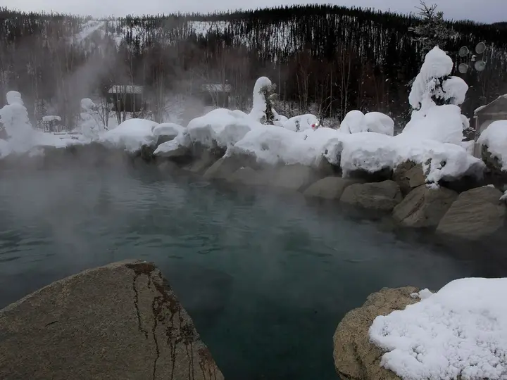
Kanuti Hot Springs is the opposite of a resort. There is no tub, no cabin, no sign and no path. Hot water seeps from the ground in the low, spruce-and-muskeg country west of the Dalton Highway, close to the upper Kanuti River and a short way south of the Arctic Circle.
The BLM manages it as a 40-acre Area of Critical Environmental Concern. That status was given to protect the hot spring system itself, and the agency notes that, unlike most hot springs in Interior Alaska, Kanuti has never been built on or developed commercially. That is the appeal. You are soaking in something close to its natural state.
It is also the catch. The BLM says the water can reach 150°F66°C, and older federal thermal spring lists give a range of about 110-151°F43-66°C at the vents. Nobody soaks at the source. Visitors move rocks to pool the water and let in cooler water from the nearby stream until it is bearable. Expect a shallow, muddy, improvised soak rather than a clear pool, and leave it as you found it.
Land status: BLM, not the refuge
Many websites describe Kanuti Hot Springs as being inside Kanuti National Wildlife Refuge. The BLM’s own description puts it on BLM public land, and the BLM’s national land-status data for these coordinates also shows BLM. Kanuti National Wildlife Refuge, about 1.6 million acres of forest and wetland along the Kanuti and Koyukuk rivers, lies to the west. If you float the Kanuti River downstream you will end up in the refuge, which has no roads or communities inside its boundaries.
The BLM Central Yukon Field Office in Fairbanks manages the Dalton Highway corridor and the springs (907-474-2200, [email protected]). For the refuge, the Bettles Ranger Station and Visitor Center (907-692-5494) gives backcountry orientations. Parcels of Native-owned land, such as allotments, can turn up anywhere in rural Alaska, so carry a current land-status map and do not camp on or cross private parcels without permission.
Getting there
Start in Fairbanks. Drive 84 miles north to Livengood on the Steese and Elliott highways, then turn onto the Dalton Highway. The Dalton runs 414 miles to Deadhorse and is mostly gravel: narrow, rough, steep in places, muddy when wet and dusty when dry, with heavy truck traffic. There are no grocery stores or medical facilities along it. Check road conditions at 511.alaska.gov and carry two spare tires if you can.
Wikipedia and older guides use Mile 103 of the Dalton as the usual jumping-off point. From the road the springs are about 8 miles away to the west. There is no trail, so plan your own line on topographic maps and a GPS, and expect it to take much longer than 8 miles on a map suggests.
Visitors use two approaches:
- Winter, on skis. Frozen ground and rivers make travel far easier than summer bog. Alaska statutes ban off-road vehicles, snowmachines included, within 5 miles on either side of the highway north of the Yukon River, so you will ski or snowshoe at least the first 5 miles and in practice the whole way.
- Summer, by packraft and on foot. Trip reports describe packrafting the Kanuti River from the highway to the springs and then hiking back over the ridges to the road. It is wet, buggy, slow travel through brush and tussocks, and the river may be shallow or full of sweepers.
When to go
Late winter (February to April) is the best bet for most people. Daylight returns fast, rivers and muskeg are frozen, and soaking in hot water at -10°F−23°C feels like the reason the spring exists. Cold snaps far below zero are still possible.
Summer (June to August) brings 24-hour light but also mosquitoes, wet ground and slow walking. On a warm day the water feels hotter than you would like.
Freeze-up and break-up (roughly October and May) are the worst times: rivers are unsafe and the ground is neither frozen nor dry.
Rules and etiquette
- No fee and no permit to visit BLM land for personal recreation.
- Do not build or dig. The spring is protected precisely because it is undeveloped. Move rocks to cool a pool if you must, and put them back.
- No motor vehicles within 5 miles of the highway, including snowmachines.
- Pack everything out, including toilet paper. Camp and go to the toilet well away from the spring and the stream.
- Respect private and Native land on your route.
Where to stay nearby
You camp. Pick a dry, durable site well away from the spring. On the highway, the BLM runs four developed campgrounds along the Dalton, open from late May to early September and free of charge. The Yukon River crossing, south of Mile 103, and Coldfoot, roughly 70 miles north, have the nearest fuel, food and basic rooms. Coldfoot is also home to the Arctic Interagency Visitor Center, where staff can talk through current conditions.
Safety notes
- Scalding water: At up to 150°F66°C the source can burn badly in seconds. Test with a hand, never put your head under, and keep children and dogs away from the vents.
- No help nearby: There is no cell service anywhere near the springs and only scattered coverage on the Dalton. Carry a satellite messenger, tell someone your route and return time, and be ready to self-rescue.
- Cold: A wet body in winter loses heat fast. Have dry clothing, a warm sleeping bag and a stove ready before you get out of the water.
- Navigation: No trail and few landmarks. Map, compass and GPS, and the skill to use them, are essential.
- Bears and moose: Both are common. Store food properly, make noise in thick brush and give moose a very wide berth in late winter, when they are stressed and short-tempered.
- The road: The drive is a real hazard in its own right. Slow down for trucks, pull over to let them pass, and keep headlights on.
Map and nearby springs
GPS: 66.34167, -150.84556
Kanuti Hot Springs: common questions
Where is Kanuti Hot Springs?
In Interior Alaska, about 8 miles west of the Dalton Highway and a little south of the Arctic Circle. Older guides use Mile 103 of the Dalton as the starting point. The nearest services are at the Yukon River crossing to the south and Coldfoot to the north.
Is Kanuti Hot Springs in Kanuti National Wildlife Refuge?
Many guides say so, but the BLM describes it as a 40-acre Area of Critical Environmental Concern on BLM public land, and BLM land-status maps agree. The refuge lies to the west. Either way, it is federal public land with no fee.
Can you drive to Kanuti Hot Springs?
No. There is no road or trail. Summer visitors usually packraft the Kanuti River and hike, and winter visitors ski in. Alaska law bans off-road vehicles, including snowmachines, within 5 miles either side of the Dalton Highway north of the Yukon River.
How hot is Kanuti Hot Springs?
The water comes out of the ground at about 150°F66°C according to the BLM, and older federal lists give 110-151°F43-66°C. It is too hot to sit in where it emerges, so people pool it with cooler stream water.
Is there anywhere to stay near Kanuti Hot Springs?
Only your own tent. The BLM runs a few free developed campgrounds along the Dalton Highway from late May to early September, and Coldfoot and the Yukon River crossing have basic lodging.
Closest hot springs to Kanuti Hot Springs
106°F41°C
Wild & natural
Near Manley Hot Springs
Resort or spa
Near Fairbanks
Resort or spa
Near Ruby
Wild & natural
All hot springs in AlaskaAll hot springs in United StatesOpen the full map